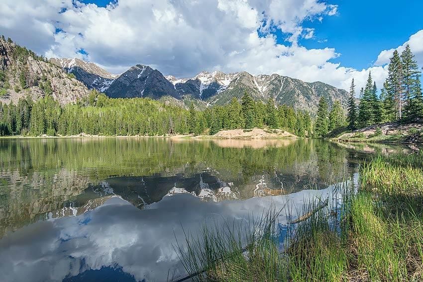
Hikers will face some unforgettable adventures by heading for many of the trails near Durango. The town itself offers you a kaleidoscope of color, particularly during the fall.
Located in southwest Colorado, it is just a short drive from Four Corners Monument, where New Mexico, Arizona, Utah, and Colorado meet.
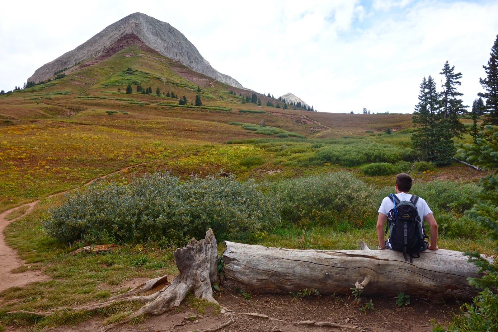
Most hikers agree that these trails are desirable if you are looking for a quick-hour hike or seeking all-day challenges.
Here is our list of the 14 best Durango hiking trails!
1. Animas City Mountain Trail:
The Animas City Mountain Trail is a must-do hike for anyone visiting Durango. This 4.4-mile trail offers stunning panoramic views of the city and the surrounding mountains, and it’s a great way to get a workout while enjoying the beauty of the great outdoors.
The trail itself is well-maintained and easy to follow, with a few steep sections that will get your heart rate up. But the real highlight of this hike is the view from the top. From the summit, you can see for miles in every direction, taking in the sweeping vistas of the Animas River Valley and the San Juan Mountains.
One of the things I loved most about this hike was the feeling of seclusion, despite being just minutes from downtown Durango. As I made my way up the trail, I felt like I was miles away from the hustle and bustle of civilization, surrounded by the quiet beauty of nature.
Another highlight of this hike is the abundance of wildlife you’ll see along the way. I spotted several deer and even a fox during my hike, which added to the sense of being out in the wilderness.
Overall, I highly recommend the Animas City Mountain Trail to anyone looking for a beautiful hike in Durango. Whether you’re a seasoned hiker or just starting out, this trail offers something for everyone. Just be sure to bring plenty of water and sunscreen, as there isn’t much shade along the way.
- Distance: The Animas City Mountain Trail is 4.4 miles (7.1 km) round-trip.
- Elevation Gain: The trail has an elevation gain of approximately 1,000 feet (305 meters), with a maximum elevation of 8,400 feet (2,560 meters).
- Route Type: The trail is an out-and-back route that begins at the trailhead on Junction Street and follows a well-marked path to the summit of Animas City Mountain.
- Rating: The Animas City Mountain Trail is rated as moderate in difficulty. While the trail is well-maintained, it does include some steep sections that can be challenging for novice hikers. However, the stunning views from the summit make the effort well worth it.
2. Engineer Mountain Trail:
If you’re looking for a challenging but rewarding hike in the Durango area, the Engineer Mountain Trail is an excellent choice. This 7.8-mile (12.5 km) trail takes you through some of the most stunning alpine scenery in Colorado, culminating in breathtaking views from the summit of Engineer Mountain.
The trail starts in a dense aspen grove, which provides a welcome respite from the heat on a hot summer day. From there, it climbs steadily through alpine meadows and over rocky terrain, with plenty of switchbacks and steep sections to keep you challenged. Along the way, you’ll pass several small waterfalls and cascading streams, adding to the beauty of the hike.
The final push to the summit of Engineer Mountain is the most challenging part of the hike, with a steep and rocky climb to an elevation of 12,968 feet (3,953 meters). But the views from the top are simply spectacular, with sweeping vistas of the San Juan Mountains stretching out in every direction.
One of the things I loved most about this hike was the sense of remoteness and wilderness. The trail is well-marked and well-maintained, but you’ll feel like you’re far from civilization as you make your way through the rugged terrain.
Overall, I highly recommend the Engineer Mountain Trail to experienced hikers looking for a challenging and rewarding hike in the Durango area. Just be sure to bring plenty of water and snacks, as the hike can take several hours to complete.
- Distance: The Engineer Mountain Trail is 7.8 miles (12.5 km) round-trip.
- Elevation Gain: The trail has an elevation gain of approximately 2,800 feet (853 meters), with a maximum elevation of 12,968 feet (3,953 meters).
- Route Type: The trail is an out-and-back route that begins at the Engineer Mountain trailhead near the town of Silverton, Colorado.
- Rating: The Engineer Mountain Trail is rated as difficult in difficulty due to its steep and rocky terrain, high elevation, and challenging climb to the summit. This hike is recommended for experienced hikers who are in good physical condition and have appropriate gear and supplies.
3. Purgatory Flats Trail:
The Purgatory Flats Trail is a delightful hike that offers a little bit of everything for outdoor enthusiasts. This 6.5-mile (10.5 km) trail takes you through lush meadows, dense forests, and alongside babbling streams, making it a perfect way to explore the natural beauty of the Durango area.
The trail starts off at the Purgatory Flats trailhead and follows a gently sloping path through a grassy meadow, offering stunning views of the surrounding mountains. As you continue along the trail, you’ll pass through dense stands of aspen and pine trees, with occasional glimpses of the nearby creek.
One of the highlights of this hike is the abundance of wildlife you’ll see along the way. I spotted several deer, a family of wild turkeys, and even a few playful otters splashing around in the creek.
The trail eventually climbs up to a ridge, providing sweeping views of the surrounding landscape. From there, it descends into a lush meadow and follows the creek back to the trailhead.
Overall, I highly recommend the Purgatory Flats Trail to anyone looking for a scenic and enjoyable hike in the Durango area. The trail is well-marked and easy to follow, and it offers a great way to experience the natural beauty of Colorado.
- Distance: The Purgatory Flats Trail is 6.5 miles (10.5 km) round-trip.
- Elevation Gain: The trail has an elevation gain of approximately 800 feet (244 meters), with a maximum elevation of 8,600 feet (2,621 meters).
- Route Type: The trail is an out-and-back route that begins at the Purgatory Flats trailhead, located just off of Highway 550 north of Durango.
- Rating: The Purgatory Flats Trail is rated as moderate in difficulty due to its moderate length and gentle slopes, with a few steeper sections. This hike is suitable for hikers of all levels, including families with children and novice hikers looking for a pleasant and accessible outdoor experience.
4. Falls Creek Trail:
The Falls Creek Trail is a must-do hike for anyone visiting the Durango area. This 4.6-mile (7.4 km) trail takes you through a stunning canyon and past several beautiful waterfalls, making it a truly memorable outdoor adventure.
The trail starts off at the Falls Creek trailhead and follows a well-marked path through dense forests and over rocky terrain. The first waterfall you’ll come across is Lower Falls, which is a perfect spot to take a break and enjoy the scenery.
As you continue along the trail, you’ll pass several more waterfalls, each more beautiful than the last. The trail can be steep in places, but the effort is definitely worth it for the stunning views of the falls and surrounding canyon.
One of the things I loved most about this hike was the sense of peace and tranquility. The sound of the rushing water and the chirping of birds provided a peaceful backdrop as I made my way through the canyon.
The trail eventually leads to Upper Falls, which is the largest waterfall on the hike and a truly breathtaking sight. The mist from the falls provides a refreshing coolness, making it a great place to rest and take in the beauty of nature.
Overall, I highly recommend the Falls Creek Trail to anyone looking for a scenic and rewarding hike in the Durango area. The trail is well-maintained and offers a great way to experience the natural beauty of Colorado.
- Distance: The Falls Creek Trail is 4.6 miles (7.4 km) round-trip.
- Elevation Gain: The trail has an elevation gain of approximately 1,000 feet (305 meters), with a maximum elevation of 8,630 feet (2,631 meters).
- Route Type: The trail is an out-and-back route that begins at the Falls Creek trailhead, located just off of Highway 550 north of Durango.
- Rating: The Falls Creek Trail is rated as moderate in difficulty due to its length and moderate elevation gain, with a few steeper sections. This hike is suitable for hikers of all levels, including families with children and novice hikers looking for a scenic and accessible outdoor experience.
5. Hermosa Creek Trail:
The Hermosa Creek Trail is a stunning hike that offers some of the most breathtaking views in the Durango area. This 13.4-mile (21.6 km) trail takes you through towering pine forests, alongside crystal clear streams, and over expansive meadows, providing a true taste of the Colorado wilderness.
The trail begins at the Hermosa Creek trailhead and follows a well-maintained path through dense forests and over rocky terrain. The trail can be steep in places, but the effort is worth it for the incredible views of the surrounding mountains and valleys.
As you continue along the trail, you’ll pass through a variety of terrain, including lush meadows, rocky slopes, and dense forests. The trail follows the Hermosa Creek, which provides a refreshing soundtrack as you hike.
One of the highlights of this hike is the abundance of wildflowers you’ll see along the way. I was amazed by the variety of colors and species that dotted the meadows and forest floors.
The trail eventually leads to the Hermosa Creek Wilderness Area, which is a truly special place. The wilderness area is home to a variety of wildlife, including elk, deer, and even the occasional black bear.
Overall, I highly recommend the Hermosa Creek Trail to anyone looking for a challenging and rewarding hike in the Durango area. The trail is well-marked and offers a great way to experience the natural beauty of Colorado.
- Distance: The Hermosa Creek Trail is 13.4 miles (21.6 km) round-trip.
- Elevation Gain: The trail has an elevation gain of approximately 1,500 feet (457 meters), with a maximum elevation of 9,810 feet (2,990 meters).
- Route Type: The trail is an out-and-back route that begins at the Hermosa Creek trailhead, located just off of Highway 550 north of Durango.
- Rating: The Hermosa Creek Trail is rated as difficult in difficulty due to its length and moderate to steep elevation gain, with several challenging sections. This hike is suitable for experienced hikers and those looking for a challenging outdoor adventure.
6. Ice Lakes Trail:
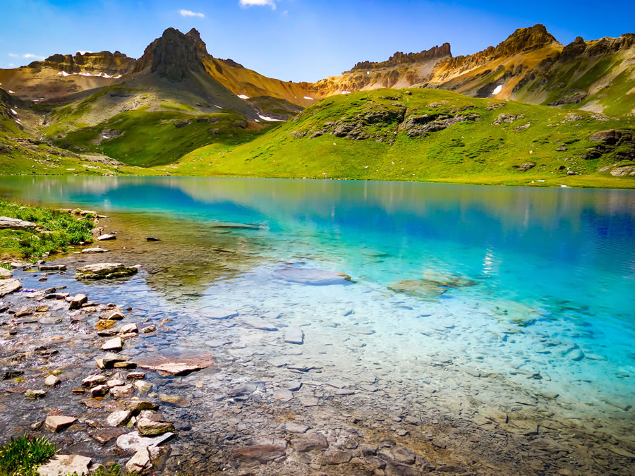
The Ice Lakes Trail is one of the most stunning hikes in the Durango area. This 7.6-mile (12.2 km) trail takes you through alpine meadows and past crystal-clear lakes, providing breathtaking views of the San Juan Mountains.
The trail begins at the South Mineral Campground and climbs steeply up the mountainside. The first section of the trail is strenuous, with several switchbacks and steep inclines. However, the effort is worth it for the incredible views of the surrounding mountains and valleys.
As you continue along the trail, you’ll pass through a variety of terrain, including dense forests, rocky slopes, and alpine meadows. The trail follows a series of switchbacks, which can be challenging but are well-maintained and easy to follow.
One of the highlights of this hike is the stunning Ice Lake, which is a bright turquoise color and absolutely breathtaking. The lake is surrounded by soaring peaks, providing a truly awe-inspiring backdrop.
Beyond Ice Lake, the trail continues to climb to Island Lake, which is equally stunning. The lake is nestled in a high alpine basin, surrounded by rugged peaks and towering cliffs.
Overall, I highly recommend the Ice Lakes Trail to anyone looking for a challenging and rewarding hike in the Durango area. The trail is well-marked and offers a great way to experience the natural beauty of Colorado.
- Distance: The Ice Lakes Trail is 7.6 miles (12.2 km) round-trip.
- Elevation Gain: The trail has an elevation gain of approximately 2,500 feet (762 meters), with a maximum elevation of 12,275 feet (3,741 meters).
- Route Type: The trail is an out-and-back route that begins at the South Mineral Campground, located off of Highway 550 north of Durango.
- Rating: The Ice Lakes Trail is rated as difficult in difficulty due to its steep elevation gain and challenging terrain, with several switchbacks and steep sections. This hike is suitable for experienced hikers and those looking for a challenging outdoor adventure.
7. Spud Lake Trail (aka Potato Lake Trail):
The Spud Lake Trail is a beautiful hike that takes you through dense forests and along the shores of serene mountain lakes. This 4.2-mile (6.8 km) trail is a hidden gem in the Durango area and provides a peaceful escape from the hustle and bustle of everyday life.
The trail begins at the Spud Lake trailhead and follows a gentle path through lush forests and over small streams. The trail is well-maintained and easy to follow, making it a great choice for hikers of all levels.
As you continue along the trail, you’ll pass by several small lakes and ponds, each one more beautiful than the last. The lakes are surrounded by towering peaks, providing a stunning backdrop for your hike.
One of the highlights of this hike is Spud Lake itself. The lake is a deep blue color and is surrounded by dense forests and rugged cliffs. The lake provides a peaceful spot for a picnic or a quick swim on a hot summer day.
Overall, I highly recommend the Spud Lake Trail to anyone looking for a peaceful and scenic hike in the Durango area. The trail is easy to follow and offers a great way to experience the natural beauty of Colorado.
- Distance: The Spud Lake Trail is 4.2 miles (6.8 km) round-trip.
- Elevation Gain: The trail has an elevation gain of approximately 800 feet (244 meters), with a maximum elevation of 9,600 feet (2,926 meters).
- Route Type: The trail is an out-and-back route that begins at the Spud Lake trailhead, located off of Highway 550 north of Durango.
- Rating: The Spud Lake Trail is rated as moderate in difficulty due to its gentle incline and relatively short distance. This hike is suitable for hikers of all levels, including families with young children.
8. Telegraph Trail:
The Telegraph Trail is a scenic hike that takes you through a diverse landscape of meadows, forests, and rocky outcroppings. This 6.2-mile (10 km) trail is a great option for those looking for a moderate hike with plenty of stunning views.
The trail begins at the Horse Gulch Trailhead and winds through a series of switchbacks, offering stunning views of the surrounding mountains and valleys. The trail is well-maintained and easy to follow, making it a great choice for hikers of all levels.
As you continue along the trail, you’ll pass through dense forests and open meadows, each one offering a unique view of the surrounding landscape. The trail also takes you past several rock formations, including the impressive Telegraph Rock.
One of the highlights of this hike is the stunning view of the Animas River Valley. The trail provides panoramic views of the valley, including the town of Durango and the surrounding mountains.
Overall, I highly recommend the Telegraph Trail to anyone looking for a scenic and moderately challenging hike in the Durango area. The trail is well-marked and offers a great way to experience the natural beauty of Colorado.
- Distance: The Telegraph Trail is 6.2 miles (10 km) round-trip.
- Elevation Gain: The trail has an elevation gain of approximately 1,200 feet (366 meters), with a maximum elevation of 7,650 feet (2,332 meters).
- Route Type: The trail is an out-and-back route that begins at the Horse Gulch Trailhead, located off of East 3rd Avenue in Durango.
- Rating: The Telegraph Trail is rated as moderate in difficulty due to its steady incline and rocky terrain. This hike is suitable for hikers with some experience and those looking for a moderately challenging outdoor adventure.
9. Twilight Peaks Trail:
The Twilight Peaks Trail is a stunning hike that takes you through some of the most beautiful alpine scenery in the Durango area. This 12.2-mile (19.6 km) trail is a great option for experienced hikers looking for a challenging, high-altitude adventure.
The trail begins at the end of the Andrews Lake Road and quickly climbs through dense forests and up rocky switchbacks. As you ascend, you’ll be rewarded with stunning views of the surrounding peaks and valleys.
One of the highlights of this hike is the stunning views of the Twilight Peaks themselves. These rugged peaks rise over 13,000 feet (3,962 meters) and are a stunning sight to behold. The trail takes you to the base of the peaks, providing a unique perspective on these towering mountains.
As you continue along the trail, you’ll pass through several high-alpine meadows, each one offering a unique view of the surrounding landscape. The trail also takes you past several mountain lakes, including the beautiful Emerald Lake.
Overall, I highly recommend the Twilight Peaks Trail to experienced hikers looking for a challenging, high-altitude adventure. The trail is well-maintained but requires a good level of fitness and stamina to complete.
- Distance: The Twilight Peaks Trail is 12.2 miles (19.6 km) round-trip.
- Elevation Gain: The trail has an elevation gain of approximately 3,600 feet (1,097 meters), with a maximum elevation of 12,650 feet (3,855 meters).
- Route Type: The trail is an out-and-back route that begins at the Andrews Lake Road trailhead, located off of Highway 550 north of Durango.
- Rating: The Twilight Peaks Trail is rated as difficult in difficulty due to its high altitude, rocky terrain, and steep inclines. This hike is suitable for experienced hikers with good fitness levels and those looking for a challenging outdoor adventure.
10. Vallecito Creek Trail:
The Vallecito Creek Trail is a beautiful hike that takes you deep into the heart of the Weminuche Wilderness. This 19.3-mile (31.1 km) trail is a great option for experienced hikers looking for a challenging, multi-day adventure.
The trail begins at the Vallecito Trailhead and quickly climbs through dense forests and up rocky switchbacks. As you ascend, you’ll be rewarded with stunning views of the surrounding peaks and valleys.
One of the highlights of this hike is the stunning views of the Vallecito Creek itself. The trail follows the creek for much of the way, providing a peaceful soundtrack to your journey. You’ll also pass through several high-alpine meadows, each one offering a unique view of the surrounding landscape.
As you continue along the trail, you’ll pass several beautiful mountain lakes, including Johnson Creek, Emerald Lake, and Sunlight Lake. These lakes are great spots to rest and take in the surrounding beauty.
Overall, I highly recommend the Vallecito Creek Trail to experienced hikers looking for a challenging, multi-day adventure. The trail is well-maintained but requires good fitness and stamina to complete.
- Distance: The Vallecito Creek Trail is 19.3 miles (31.1 km) one-way, making it a great option for a multi-day backpacking trip.
- Elevation Gain: The trail has an elevation gain of approximately 4,600 feet (1,402 meters), with a maximum elevation of 11,480 feet (3,499 meters).
- Route Type: The trail is an out-and-back route that begins at the Vallecito Trailhead, located off of Highway 550 north of Durango.
- Rating: The Vallecito Creek Trail is rated as difficult in difficulty due to its length, high altitude, rocky terrain, and steep inclines. This hike is suitable for experienced hikers with good fitness levels and those looking for a challenging outdoor adventure.
11. Animas River Trail
The Animas River Trail is a beautiful and scenic hike that follows the Animas River through the heart of Durango. This 7.8-mile (12.6 km) trail is perfect for hikers, bikers, and walkers of all ages and skill levels.
The trail begins at the Santa Rita Park Trailhead and meanders through the city, providing stunning views of the Animas River and the surrounding mountains. Along the way, you’ll pass through several parks and recreational areas, including Rotary Park, Schneider Park, and Animas City Park.
One of the highlights of this trail is the opportunity to see wildlife up close. You may see ducks and other waterfowl swimming in the river, as well as beavers, muskrats, and other mammals. You may even spot a bald eagle soaring overhead.
The Animas River Trail is a great way to experience Durango’s natural beauty and get some exercise at the same time. Whether you’re looking for a leisurely stroll or a long bike ride, this trail has something for everyone.
- Distance: The Animas River Trail is 7.8 miles (12.6 km) one-way, making it a great option for a leisurely day hike or bike ride.
- Elevation Gain: The trail has a minimal elevation gain, making it a great option for hikers and bikers of all skill levels.
- Route Type: The trail is an out-and-back route that begins at the Santa Rita Park Trailhead and follows the Animas River through Durango.
- Rating: The Animas River Trail is rated as easy in difficulty, making it a great option for families with children and those looking for a leisurely outdoor activity.
12. Rim Trail/Campus Loop
The Rim Trail/Campus Loop is a must-do hike for anyone visiting Fort Lewis College in Durango, Colorado. This trail offers stunning views of the Animas River Valley and the La Plata Mountains, making it a perfect spot for photography enthusiasts and nature lovers.
The hike is about 3.5 miles (5.6 km) in length and has a moderate elevation gain of approximately 600 feet (183 m). The route takes hikers along the college campus, through pine forests, and over rocky terrain, providing a diverse range of scenery along the way.
One of the highlights of this trail is the panoramic view of the surrounding area from the Rim Trail overlook. From here, hikers can take in stunning views of the Animas River, the city of Durango, and the surrounding mountains.
The Rim Trail/Campus Loop is a great way to explore the Fort Lewis College campus and the surrounding wilderness. This trail is ideal for families with children and anyone looking for a moderate outdoor activity.
- Distance: The Rim Trail/Campus Loop is approximately 3.5 miles (5.6 km) in length, making it a great option for a shorter hike.
- Elevation Gain: The trail has a moderate elevation gain of approximately 600 feet (183 m), making it a good option for hikers looking for a bit of a challenge.
- Route Type: The trail is a loop route that begins and ends at the Fort Lewis College campus and takes hikers through pine forests and over rocky terrain.
- Rating: The Rim Trail/Campus Loop is rated as moderate in difficulty, making it a great option for hikers and families with children looking for a bit of a challenge.
13. Haflin Creek Trail
The Haflin Creek Trail is a hidden gem in the San Juan Mountains near Durango, Colorado. This scenic trail offers hikers a peaceful escape from the hustle and bustle of city life, with breathtaking views of the surrounding peaks and valleys.
The trail is approximately 5.5 miles (8.8 km) long and has a moderate elevation gain of approximately 1,200 feet (366 m). The route follows a babbling creek, meanders through wildflower-filled meadows, and winds through dense pine forests. The trail offers a great opportunity to view the abundant wildlife in the area, including mule deer, elk, and black bears.
One of the highlights of the Haflin Creek Trail is the stunning waterfall located about halfway along the route. This impressive natural feature offers a great spot for hikers to rest and take in the beauty of the surroundings.
The Haflin Creek Trail is a great option for hikers of all levels, including families with children. The trail is well-marked and offers a great opportunity to experience the stunning beauty of the San Juan Mountains.
- Distance: The Haflin Creek Trail is approximately 5.5 miles (8.8 km) long, making it a good option for hikers looking for a moderate-length hike.
- Elevation Gain: The trail has a moderate elevation gain of approximately 1,200 feet (366 m), making it a bit of a challenge, but still accessible for hikers of all levels.
- Route Type: The trail is an out-and-back route that follows a creek and winds through pine forests and meadows.
- Rating: The Haflin Creek Trail is rated as moderate in difficulty, making it a great option for hikers of all levels. The stunning waterfall and abundance of wildlife make this trail a must-do for nature lovers.
14. Goulding Creek Trail
The Goulding Creek Trail is a hidden gem located near Durango, Colorado. This 3.2-mile (5.1 km) out-and-back trail offers hikers a moderate hike with stunning views of the surrounding San Juan Mountains.
The trail starts with a gentle climb through a dense forest, offering hikers a chance to enjoy the fresh mountain air and the sounds of the forest. As the trail continues, hikers are rewarded with stunning views of the Goulding Creek and the surrounding peaks. The trail follows the creek and offers plenty of opportunities to stop and enjoy the views.
The Goulding Creek Trail has a moderate elevation gain of approximately 900 feet (274 m), making it a good option for hikers of all levels. The trail is well-marked and easy to follow, with clear signs pointing the way.
One of the highlights of the Goulding Creek Trail is the stunning waterfall located near the end of the trail. The waterfall offers hikers a great spot to take a break and enjoy the beauty of the area.
Overall, the Goulding Creek Trail is a great option for hikers looking for a moderate hike with stunning views of the San Juan Mountains.
- Distance: The Goulding Creek Trail is 3.2 miles (5.1 km) long, making it a good option for hikers looking for a moderate-length hike.
- Elevation Gain: The trail has a moderate elevation gain of approximately 900 feet (274 m), making it a good option for hikers of all levels.
- Route Type: The trail is an out-and-back route that follows Goulding Creek and offers stunning views of the surrounding peaks.
- Rating: The Goulding Creek Trail is rated as moderate in difficulty, making it a great option for hikers of all levels. The stunning waterfall and views of the surrounding peaks make this trail a must-do for nature lovers.